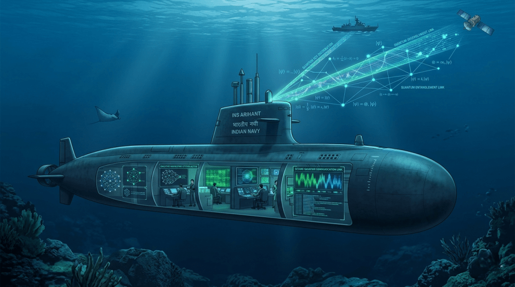
For more than half a century, the deep ocean stood as the ultimate military hiding place. Once a nuclear-powered or advanced conventional submarine slipped beneath the waves, it vanished into a world of absolute shadow. Stealth was a binary condition: you were either hidden, or dead. That era of absolute opacity is ending.
The undersea battlespace is undergoing its most profound transformation since the Cold War. Two parallel technological shifts are fundamentally altering how navies hunt and how submarines hide. On one hand, persistent, artificial-intelligence-driven sensor networks are mapping the ocean’s depths, threatening to make traditional stealth prohibitively difficult. On the other hand, a quiet revolution in quantum physics and atomic timekeeping is decoupling the submarine from the sky, aiming to eliminate its reliance on vulnerable satellite navigation.
The interaction between these two trends will dictate the balance of naval power across the Indo-Pacific for decades to come.
Part I: The End of the Silent Ocean
Historically, anti-submarine warfare (ASW) was a game of cat-and-mouse. An adversary navy would drop sonobuoys from aircraft or deploy a single surface vessel to stream a towed sonar array, hoping to cross paths with a hidden sub. It was episodic, localized, and heavily favored the hider.
Today, that approach is being replaced by a permanent, interconnected fabric of sensors—often referred to in defense circles as the ‘Underwater Great Wall’.
Instead of searching for a submarine after the fact, modern undersea surveillance aims to continuously monitor entire maritime regions. This architecture relies on several layers:
- Fixed Seabed Arrays: Chains of highly sensitive hydrophones (underwater microphones) bolted to the ocean floor at critical geographical choke points. These arrays listen continuously for the distinct acoustic signatures, or “tonals,” of passing platforms.
- Persistent Unmanned Systems: Fleet of autonomous underwater vehicles (UUVs) and wave-powered gliders that patrol maritime corridors for months at a time, gathering environmental data and listening for anomalies.
- Telemetry Buoys and Satellites: Floating stations that collect data from seabed sensors and UUVs, instantly beaming that information via satellite links back to mainland analysis centers.
- Artificial Intelligence and Machine Learning: The true engine of the modern sensing network. The ocean is incredibly noisy, filled with whale songs, cracking shrimp, and commercial shipping traffic. AI algorithms excel at filtering out this background clutter, rapidly isolating the faint, rhythmic hum of a military submarine that would previously have gone unnoticed.
The Strategic Geography of the Indo-Pacific
This sensing revolution is playing out with distinct geopolitical flavors across Asia. China has invested heavily in creating a dense, multi-layered surveillance network within its immediate waters—the South and East China Seas. By turning these areas into highly monitored tactical bottlenecks, Beijing aims to deny foreign submarines easy access to its coastline.
However, the Indian Ocean presents an entirely different challenge. It is vast, deep, and politically fractured. A contiguous, unbroken seabed sensor network across the entire Indian Ocean is financially and practically impossible.
To overcome this, China’s strategy focuses on fragmentation and leverage. Rather than monitoring the whole ocean, Beijing is placing telemetry buoys and UUV patrol corridors at specific choke points—such as the Malacca, Sunda, and Lombok straits—and along key trade approaches.
In response, India is fortifying its own defensive perimeter. New Delhi is actively weaponizing regional geography by deploying fixed acoustic arrays around the strategic Andaman and Nicobar Islands, creating a localized sensor line across the mouth of the Malacca Strait. Because India cannot police the entire expanse unilaterally, it increasingly relies on minilateral intelligence-sharing agreements with partners like the United States, Japan, and Australia to patch the gaps in its maritime domain awareness.
Part II: The Paradox of the Skies
While sensor networks threaten submarines from below, an entirely different vulnerability menaces them from above: the critical requirement for position, navigation, and timing (PNT) data.
To navigate safely, launch cruise missiles, or coordinate with a wider fleet, a submarine must know exactly where it is and what time it is. Beneath the waves, a submarine relies on an Inertial Navigation System (INS)—a complex array of accelerometers and gyroscopes that tracks the vessel’s movements from a known starting point, calculating its position through dead reckoning.
The problem is inertial drift, Over hours and days, tiny measurement errors in the INS compound. Left unchecked, a submarine’s onboard map can drift by miles, turning a precise navigation route into a dangerous guessing game.
To correct this drift, submarines must periodically ascend to periscope depth, extend a mast, and capture a radio signal from Global Navigation Satellite Systems (GNSS) like the American GPS.
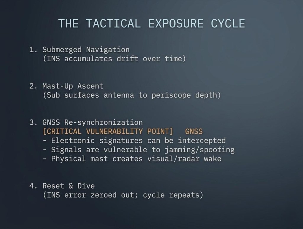
This “mast-up” event is an acute tactical vulnerability. It is vital to understand that satellites do not track submarines acoustically. Rather, the act of surfacing an antenna breaks the submarine’s radio silence, exposing it to electronic interception, radar detection, and satellite observation. Furthermore, relying on civilian or foreign satellite constellations leaves the submarine exposed to electronic warfare tactics such as GPS jamming (blocking the signal) or spoofing (broadcasting fake coordinates).
India’s Structural Exposure
This reliance on external satellite navigation highlights a significant strategic vulnerability for India: the current limitations of its domestic satellite network, NavIC (Navigation with Indian Constellation).
NavIC was designed to provide independent, sovereign PNT data to India and its immediate surroundings. However, the system has faced operational setbacks, including a limited number of active satellites and degraded service consistency.
Consequently, Indian submarines operating far from home waters cannot yet depend fully on NavIC. To maintain mission-acceptable accuracy, they must frequently fall back on foreign systems like the American GPS. In a high-intensity conflict, this reliance on an external, potentially contestable satellite architecture creates an exploitable weak point. If an adversary disrupts the GPS signal or compromises the timebase, an Indian submarine’s operational freedom is immediately degraded.
Part III: The Quantum Shield
To counter the growing threat of satellite vulnerability, naval research has turned to advanced physics. The goal is simple yet revolutionary: create a navigation architecture so stable and precise that a submarine never needs to look at the sky again.
Sensationalized headlines often describe these developments as immediate “GPS killers.” The reality is more nuanced. These technologies are currently shifting from university laboratories into experimental prototypes, and their initial military rollouts will feature hybrid architectures rather than an immediate, total replacement of existing systems.
The core of this push relies on two distinct quantum-era technologies:
1. Quantum Inertial Units
Quantum IMUs replace the mechanical mirrors and fibers of classical navigation with atom interferometers. These systems use lasers to cool clouds of atoms down to temperatures just above absolute zero, measuring how these hyper-stable atomic clouds shift in response to the vessel’s movement.
A mature quantum IMU can reduce navigation drift by an order of magnitude or more compared to current systems. Instead of needing a satellite update every few hours to correct its position, a quantum-equipped submarine could maintain extreme navigation accuracy for days or even a full week without breaking cover.
2. Atomic and Nuclear Clocks
An INS cannot calculate position accurately without perfect timekeeping. Navies are currently deploying ‘Chip-Scale Atomic Clocks (CSACs)’ directly onto naval platforms to ensure highly stable internal timing.
Looking further ahead, researchers are pursuing ‘thorium-229 nuclear clocks’. Researchers from the Xinjiang Technical Institute of Physics and Chemistry claimed to have achieved a record 145.2-nanometer ultraviolet wavelength needed to activate thorium-229 nuclear clocks. This is very close to the ≈148‑nm transition needed to excite the low‑energy isomer state in thorium‑229 (²²⁹Th).
By utilizing high-energy vacuum ultraviolet (VUV) lasers to manipulate the nucleus of a thorium atom, these clocks promise long-term timing stability that leaves traditional atomic clocks far behind.
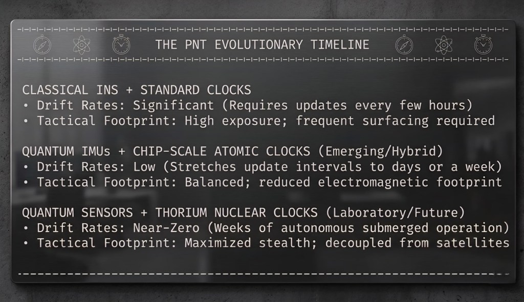
If successfully integrated, a combined quantum IMU and nuclear clock system would fundamentally alter undersea tactics. By extending submerged autonomy from hours to weeks, it would radically complicate an adversary’s ASW planning, turning predictable patrol corridors back into vast oceans of uncertainty.
Part IV: The Path Forward for Indian Naval Strategy
The intersection of a more transparent ocean and these new quantum navigation capabilities requires a sharp reassessment of India’s naval procurement and operational doctrines. To maintain a credible underwater deterrent and counter China’s growing footprint in the Indian Ocean, India must execute a balanced, multi-tiered strategy.
Short-Term Priorities: Hardening the Core
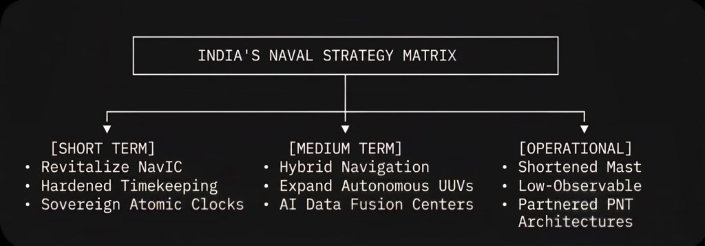
India’s immediate focus must be the restoration and stabilization of its sovereign PNT capability. This means rapidly replacing and expanding the NavIC satellite constellation to guarantee continuous, un-jammable regional service. Concurrently, the Indian Navy must prioritize installing high-grade, domestic atomic clocks across all active naval platforms to ensure resilient internal timekeeping, while aggressively pursuing counter-spoofing and counter-jamming technologies for existing fleets.
Medium-Term Horizon: Embracing the Hybrid
Because true quantum sensors remain complex and difficult to manufacture, India cannot afford to wait for a turnkey solution. The medium-term procurement strategy must focus on ‘hybrid navigation architecture’. These systems combine existing high-end mechanical INS with early-generation quantum sensors and bathymetric terrain-matching—using the topography of the ocean floor as a secondary map to verify position. Additionally, India should accelerate its investments in domestic artificial intelligence data centers to quickly process information from its own growing networks of autonomous underwater gliders.
Doctrinal Innovation: Changing How We Fight
Technology alone will not win the undersea battle; doctrine must adapt. Indian submarine operations must shift to assume they are being monitored by adversarial sensing networks. This requires:
- Enforcing highly restricted, ultra-short surfacing windows for satellite synchronization.
- Deploying low-observable, mast-based, or floating tethered antennas that minimize visual and electronic cross-sections during updates.
- Integrating shared allied PNT architectures to ensure that if one system is compromised or jammed, alternative reference data can be pulled seamlessly from a trusted partner network.
Conclusion: The New Equilibrium
The “transparent ocean” thesis is a powerful warning, but it is not an absolute law. The open ocean is mind-bogglingly vast, and complete, continuous surveillance remains a luxury that can only be maintained in localized, high-priority sectors like narrow straits and shallow coastlines. Away from these bottlenecks, in the vast deep-water expanses of the open sea, concealment is still very much possible.
Ultimately, the future of underwater warfare will not be defined by a single, definitive breakthrough. It will be shaped by a continuous, iterative wrestling match between sensing and autonomy.
As persistent surveillance networks make classical underwater stealth more difficult and expensive to maintain, advanced onboard navigation tools like quantum IMUs and ultra-stable atomic clocks will step in to decouple the submarine from the vulnerabilities of the sky. The navies that master the integration of these two forces—using advanced sensing to map their shores while employing quantum autonomy to vanish into the deep—will command the true silent depths of tomorrow.


Leave a Reply